This Combo includes:
DJI Mavic 3 Multispectral
DJI Care Enterprise Basic (Mavic 3M) NZ
DJI Mavic 3 Enterprise Series Battery Kit
FEATURES
NEW STANDARD FOR PORTABLE MULTISPECTRAL DRONES
The DJI Mavic 3 Multispectral is designed for precision agriculture and environmental monitoring.
It is equipped with a multispectral imaging system that quickly captures crop growth information to achieve more effective crop production.
The Mavic 3M includes an RTK module that achieves centimetre-level positioning.
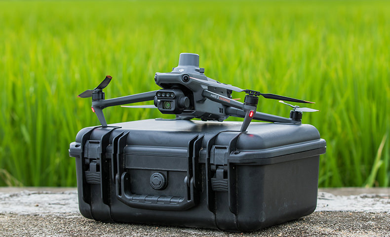
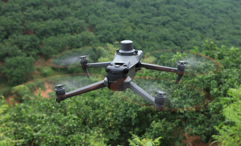
The Mavic 3 Multispectral is a highly-portable drone: It’s foldable design and 951g weight means it can be carried in a bag to enable farmers to carry out operations at anytime.
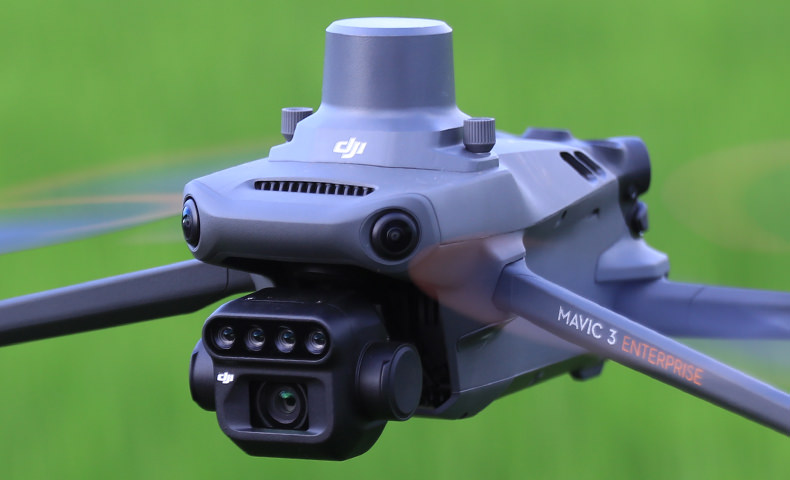
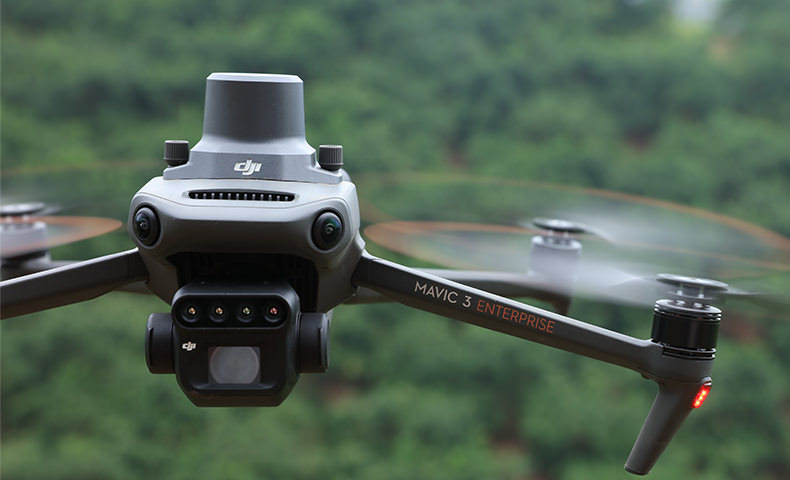
MAVIC 3M CAMERAS
The DJI Mavic 3M has a newly-upgraded imaging system with one 20MP RGB camera and four 5MP multispectral cameras. This enables applications such as high-precision aerial surveying, crop growth monitoring, and natural resource surveys.
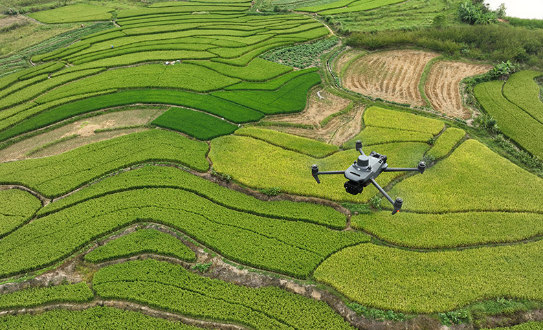
It has 43 minutes of flight time and can complete the surveying and mapping operations of an area as vast as 2 square kilometers in a single flight.
MULTISPECTRAL CAMERAS
The Mavic 3M has four 5MP multispectral cameras. Infact, the Mavic 3M is the world’s smallest 4-band multispectral drone camera.
Its built-in camera array combines Green, Red, Red Edge, and Near Infrared sensors.
Near Infrared: 860 nm ± 26 nm
Red: 650 nm ± 16 nm
Red Edge: 730 nm ± 16 nm
Green: 560nm ± 16 nm
These sensors support the NDVI, GNDVI, and NDRE vegetation indexes to provide farmers with vital information.
NDVI: Makes it possible to detect plants under stress, differentiate between crops, and determine at which stage they are in their growing cycle.
NDRE: Provides insights on chlorophyll content in leaves.
GNDVI: Useful for estimating photosynthetic activity, as well as water and nitrogen content in the plant canopy.
RGB CAMERA
Beyond its multispectral capabilities, the Mavic 3M has a visual camera to empower agriculture and mapping workflows.
It features:
20MP wide camera; 4/3 CMOS
Mechanical shutter (1/2000s fastest mechanical shutter speed)
0.7 second interval shooting – high-speed burst when RGB camera is used
Large pixel size: 3.3μm pixels
Improved low-light software
With these key features, the Mavic 3M is engineered for rapid aerial surveys and data quality.
These camera specs, together with the drone’s 43 minute maximum flight time, mean that the Mavic 3M can capture data across up to 2 square kilometers in a single flight.
SUNLIGHT SENSOR
The Mavic 3M has a built-in sunlight sensor that captures solar irradiance and records it in an image file, allowing for light compensation of image data during 2D reconstruction.
This results in more accurate NDVI results, as well as improved accuracy and consistency of data acquired over time.
RTK MODULE INCLUDED
The Mavic 3M comes with an RTK module, allowing agricultural professionals to conduct high-precision aerial surveys with care, efficiency and – crucially – without the need for Ground Control Points.
The RTK module enables centimeter-level positioning. Flight control, the camera, and the RTK module sync in microseconds to accurately capture the location of each camera’s imaging centre.
ENHANCED SAFETY FEATURES
The Mavic 3M has an advanced suite of safety features.
Advanced Pilot Assistance System (APAS 5.0): State-of-the-art obstacle sensing and navigation. Data from six vision and two wide-angle sensors are assessed in real-time to detect obstacles in every direction and – when using Avoid mode – reroute your flight path accordingly.
Advanced Return To Home: This smart feature optimises your flight path to preserve battery and get your aircraft home safe and sound at the touch of a button.
AirSense: The built-in AirSense system provides an early warning of nearby crewed aircraft transmitting ADS-B signals.
O3 Transmission: The Mavic 3M comes with DJI’s O3 transmission technology. It sets the standard for video and control stability and provides a reliable link between pilot and aircraft. The Mavic 3M has a transmission range of 8km (CE).
The Mavic 3M comes with Enterprise Shield cover (Basic, 1 year).
SMART TERRAIN FOLLOW
The Mavic 3M offers Terrain Follow, helping you maintain an even altitude as you fly a survey mission across varying terrain.
By smoothly adjusting according to the terrain, you can secure the integrity of your data while it’s gathered, without having to account for any differences in post-processing.
For situations when you weren’t able to import a DSM or local elevation data pre-flight, the Mavic 3M’s collision avoidance sensors can take over by detecting the ground below and automatically adjusting flight height accordingly.
INTELLIGENT FIELD SCOUTING
The Mavic 3M can carry out automatic field scouting. The field scout images can be uploaded to the DJI SmartFarm Platform in real time through a 4G network.
It can find abnormalities, such as emergence deficiencies, weed pressure, and crop lodging in a timely manner.
It can also conduct intelligent analyses, such as cotton seedling identification and rice production testing, using AI identification for real-time sharing of crop growth information, guidance of agronomic activities, and easy management of 70 hectares of farmland by one person.
MAVIC 3E CUSTOMISATION
Build a solution tailored to your needs with Cloud API and MSDK.
Cloud API
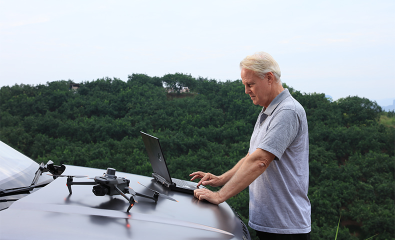
The Mavic 3M can be directly connected to a third-party cloud platform via Pilot 2’s built-in DJI Cloud API based on the MQTT protocol. There is no need to develop an app separately to enable the transmission of UAV equipment information, live streaming, photo data, and other information.
MSDK
The Mavic 3M supports Mobile SDK 5 (MSDK5) with a fully open-source production code sample. The MSDK5 makes it possible to develop a proprietary control app for UAV field patrol, smart surveying, and other scenarios, making it more user-friendly.
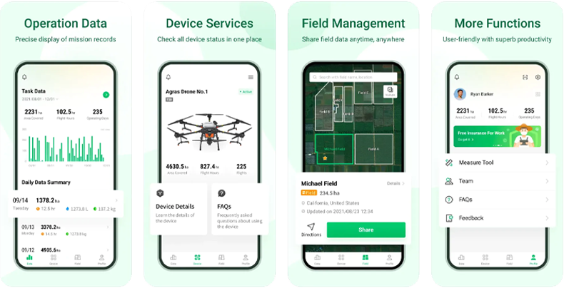
FULL SOFTWARE SUITE
The Mavic 3 Multispectral is fully compatible with the DJI SmartFarm app, allowing agriculture professionals to coordinate any data gathered with spraying and spreading operations.
SmartFarm comes with a range of features for streamlined workflows, including intuitive mission planning, a full fleet overview, field management, data assessment, and effortless collaboration between teams.
Data captured by Mavic 3M is also fully compatible with DJI Terra, so you can easily and efficiently create maps and models of your targets.
The Mavic 3M comes with a three-month DJI Terra Full licence (one device) and one-year access to the DJI SmartFarm Platform.
*Please note that the DJI Smart Agricultural Platform will be supported in Q2 of 2023.